Study Overview
Beginning in spring 2007, StreamWatch set out to study relationships between land use, stream habitat, and stream biology in the Rivanna River watershed. More than 120 volunteers, interns, environmental professionals, and academics helped gather, manage, and analyze data from 51 sites and their watersheds.
After pulling together the data, we compared stream conditions to land use. Our key findings include:
- Stream health declines predictably as land use intensifies.
- Rural and exurban streams decline rapidly with increased development.
- Only 30% of Rivanna watershed streams meet the Virginia standard. Within 20 years, a third of those healthy streams could fail the standard, based on projected land use changes.
See the sidebar to link to more information about each key finding.
Stream health at land use study sites
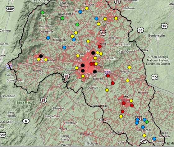
The Rivanna watershed has a wide variety of landscapes ranging from pristine forest to heavily altered urban areas. To study streams in all types of landscapes, we established data-gathering sites throughout the basin.
The map below show how stream health declines as land use intensity increases. The red areas on the landscape indicate development (more specifically, impervious cover). Notice that the healthiest streams are situated in areas of lighter development.
 Map Legend
● Very good – Natural or nearly natural biological conditions
● Good – Somewhat degraded
● Fair – Moderately degraded
● Poor – Substantially degraded
● Very Poor – Severely degraded
